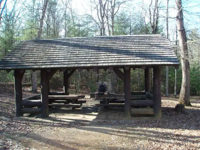
Overview This historic log picnic shelter was built by the Civilian Conservation Corps. It is located next to Comers Rock Campground in the heart of the Mount Rogers National Recreation Area. Recreation There are primitive campsites available in the adjoing campground for $5.00 per night (first-come, first-served) and …
Overview This historic log picnic shelter was built by the Civilian Conservation Corps. It is located next to Comers Rock Campground in the heart of the Mount Rogers National Recreation Area. Recreation There are primitive campsites available in the adjoing campground for $5.00 per night (first-come, first-served) and vault toilets are available. There are hiking trails in the area, including into Dry Run Wilderness, which is within walking distance from the campground and shelter. Facilities There are vault toilets available. There are picnic tables and a large fire place. Parking is available. Drinking water is not availableNatural Features Hale Lake is nearby for fishing, or stop at Comers Rock Overlook for breath taking long distance views of the valley. Nearby Attractions Hale Lake for fishing and Comers Rock Overlook for wonderful views.
Photos
Comers Rock Picnic Shelter — USFS
How to Get There
Comers Rock Picnic Shelter is located within Comers Rock Campground in Grayson/Wythe Counties, 21 miles southwest of Wytheville. From I-81 at Wytheville, take exit 67, 70, or 73 onto US 11 (Main Street). On the west end of town US 11 turns off, and Main Street becomes VA 21 south. Follow VA 21 south for 17 miles, then turn right onto gravel Forest Service Road 57 and follow it west for 4 miles to the campground.
Download your route in advance via Gaia, Caltopo, or OSM-based apps.
Recommendations adapt to the current forecast + trail stats. Use them as a starting point — local conditions, your experience, and the time of day you start all matter.
Plan Your Visit to Comer's Rock Recreation Area
Heading to Comer's Rock Recreation Area? A few things to know before you go:
Reservations: popular sites fill up fast — check Recreation.gov 6 months in advance
Fees: day-use and camping fees vary; check current rates on the official park page
Trash & pack-out: follow Leave No Trace principles
Wildlife: store food in bear boxes where provided; never feed wildlife
Weather: the 5-day forecast above is updated every 6 hours; verify just before you go
Frequently Asked Questions
Do I need a reservation for Comer's Rock Recreation Area?
No central reservation system listed for Comer's Rock Recreation Area. Check the official page (https://www.recreation.gov/camping/campgrounds/256934) for the latest entry policy and availability.
How many campsites are at Comer's Rock Recreation Area?
Comer's Rock Recreation Area has 2 campsites. Site amenities (hookups, vehicle limits, ADA access) vary — see the individual campsite pages for details.
How do I get to Comer's Rock Recreation Area?
Comers Rock Picnic Shelter is located within Comers Rock Campground in Grayson/Wythe Counties, 21 miles southwest of Wytheville. From I-81 at Wytheville, take exit 67, 70, or 73 onto US 11 (Main Street). On the west end of town US 11 turns off, and Main Street becomes VA 21 south. Follow VA 21 south for 17 miles, then turn right onto gravel Forest Service Road 57 and follow it west for 4 miles to …
How do I contact Comer's Rock Recreation Area?
You can reach the park at phone: 276-783-5196 or email: [email protected].