About KEOWEE PARK SHELTER
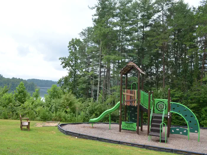
Overview Keowee Park Shelter is located within Keowee Park at W. Kerr Scott Dam and Reservoir in northwestern North Carolina.Recreation The 1,475-acre reservoir offers excellent boating, canoeing, kayaking and swimming opportunities. Anglers will find channel catfish, large and smallmouth bass, bluegill, threadfin shad, spotted bass, striped bass, and hybrid striped bass. Roughly 30 miles of multi-purpose trails surround the lake, including the Warrior Creek trails which are easily accessible from the shelter. All of the trails, including Warrior Creek, are now recognized as some of the best mountain biking trails in the country attracting riders from all corners of the world.Facilities The shelter offers six, 8-foot picnic tables. Water and electricity are not available at the shelter, please plan accordingly. Along with scenic views, you can enjoy other park amenities which include a boat ramp, playground, horseshoe pit, grill, vault toilets, and three fishing piers (one is ADA accessible).Natural Features The gentle Yadkin River flows through its scenic namesake valley in the foothills of the eastern Blue Ridge Mountains. Forests of mixed hardwoods, including sycamore, poplar, oak and hickory, cover the region. Wildlife is abundant in the valley. White-tailed deer, black bear, eastern cottontails and more can be found among the hills. Birds in the area include wild turkey, woodpeckers, Carolina chickadees, red-eyed vireo, ovenbirds, mallards and wood ducks. Contact Info For facility specific information, please call (336) 921-3390.
How to Get There
From Charlotte, North Carolina, take I-77 North (approximately 60 miles) before merging onto Highway 421 North towards Wilkesboro/Boone. Continue to Exit 286B (approximately 20 miles), turn left onto Highway 268 and continue for approximately 7.5 miles. Turn the first right after the bridge. (You will see a sign for Warrior Creek Campground.) Continue on this access road and the shelter will be straight past the gatehouse. From Winston-Salem, North Carolina, take Highway 421 North (approximately 55 miles) to Exit 286B, turn left onto Highway 268 and continue for approximately 7.5 miles. Turn the first right after the bridge. (You will see a sign for Warrior Creek Campground.) Continue on this access road and the shelter will be straight past the gatehouse. From Wilkesboro, North Carolina, head west on Main Street/Hwy 268/Hwy 18 (approximately 8.5 miles) and turn right on the Warrior Creek Campground access road (directly across from Edmiston Road). Continue on this access road and the shelter will be straight past the gatehouse.
Driving directions (Google Maps) →What to Pack for Your Stay
Tuned to the live forecast for this park.
👔 What to Wear
- 👕
Long-sleeve shirt
Synthetic or merino, sun-protective.
- 🧥
Light shell or windbreaker
Even on warm days, wind can chill (avg wind 0 mph).
- 👖
Hiking pants or convertible
Layer for variable conditions.
- 🥾
Trail runners or low boots
Comfortable, broken in.
🎒 What to Pack
- 💧
Water
Bring at least 1L of water; more in heat.
- 🍫
High-energy snacks
A snack for the trail.
- 🧴
Sun protection
Sunscreen, sunglasses, brimmed hat.
- 🩹
First-aid kit
Blister patches, ibuprofen, tape, antiseptic wipes.
- 🗺
Offline map
Download your route in advance via Gaia, Caltopo, or OSM-based apps.
Recommendations adapt to the current forecast + trail stats. Use them as a starting point — local conditions, your experience, and the time of day you start all matter.
Plan Your Visit to KEOWEE PARK SHELTER
Heading to KEOWEE PARK SHELTER? A few things to know before you go:
- Reservations: popular sites fill up fast — check Recreation.gov 6 months in advance
- Fees: day-use and camping fees vary; check current rates on the official park page
- Trash & pack-out: follow Leave No Trace principles
- Wildlife: store food in bear boxes where provided; never feed wildlife
- Weather: the 5-day forecast above is updated every 6 hours; verify just before you go
Frequently Asked Questions
Do I need a reservation for KEOWEE PARK SHELTER?
No central reservation system listed for KEOWEE PARK SHELTER. Check the official page (https://www.recreation.gov/camping/campgrounds/250008) for the latest entry policy and availability.
How do I get to KEOWEE PARK SHELTER?
From Charlotte, North Carolina, take I-77 North (approximately 60 miles) before merging onto Highway 421 North towards Wilkesboro/Boone. Continue to Exit 286B (approximately 20 miles), turn left onto Highway 268 and continue for approximately 7.5 miles. Turn the first right after the bridge. (You will see a sign for Warrior Creek Campground.) Continue on this access road and the shelter will be st…
How do I contact KEOWEE PARK SHELTER?
You can reach the park at phone: 336-921-3390.
References & Official Resources