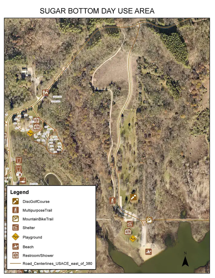
About Sugar Bottom Day Use Area
Overview Sugar Bottom Day Use Area is a day-use facility located on the shore of Coralville Lake. Coralville Lake is a multiple use project providing benefits in flood control and low flow augmentation, as well as recreation, fish and wildlife management and forest management. Coralville Lake provides many recreational opportunities, including boating, camping, hiking, mountain biking, lake and river fishing, swimming, water skiing, picnicking and hunting.Recreation Visitors enjoy Coralville Lake for boating, fishing, swimming and water activities. Anglers will find large and smallmouth bass, crappie, walleye and catfish. Several trails are within Sugar Bottom, including the Cedar Valley Nature Trail and a barrier-free asphalt trail. The Devonian Fossil Gorge is just below the dam, offering a unique opportunity to explore a 375-million-year old sea floor and discover fossil remains of sea life that once inhabited this tropical marine environment. Twenty discovery points can be found throughout the site along with a cell phone audio tour. Sugar Bottom Disc Golf Course is located in the Sugar Bottom Day Use Area and offers 18 partially wooden and open holes. Sugar Bottom Mountain Bike Trail is located in the Sugar Bottom Day Use Area and offers beginner to expert trails.Facilities The day-use location offers a large group picnic area with drinking water and electricity. Amenities include flush toilets, playground, beach, disc golf course and mountain bike trail.Natural Features Coralville Lake is located in the Iowa River Valley, just north of Iowa City. Sugar Bottom Day Use lies among a heavily wooded forest of mixed hardwood species on the east side of the lake. Wildlife is abundant throughout the project. White-tailed deer, turkeys, pheasants, waterfowl, song birds and other species roam the lands around the lake.
How to Get There
From Interstate 380 (North Liberty, Iowa), take Exit 4 towards North Liberty. Travel East on W. Penn St. for 2.2 miles. At the four way stop sign, turn left onto N. Front St./Mehaffey Bridge Road NE. Continue traveling on Mehaffey Bridge Rd. NE for 2.9 miles. Right after crossing the Mehaffey Bridge, take a right hand turn onto the Sugar Bottom Campground Access Rd. Continue on the Sugar Bottom Campground Access Rd. for 1.1 miles. The entrance to the Sugar Bottom Day Use Area will be on the left. From Highway 1 (Solon, Iowa), turn west onto 180th St. NE/E 5th St. Travel west on180th St. NE for 2.3 miles, the road will then become Mehaffey Bridge Rd. NE. Continue traveling on Mehaffey Bridge Rd. NE for 2.4 miles. Right before the Mehaffey Bridge, take a left hand turn onto the Sugar Bottom Campground Access Rd. Continue on the Sugar Bottom Campground Access Rd. for 1.1 miles. The entrance to the Sugar Bottom Day Use Area will be on the left.
Driving directions (Google Maps) →Campsites at Sugar Bottom Day Use Area
1 campsites at this campground.
What to Pack for Your Stay
Tuned to the live forecast for this park.
👔 What to Wear
- 👕
Long-sleeve shirt
Synthetic or merino, sun-protective.
- 🧥
Light shell or windbreaker
Even on warm days, wind can chill (avg wind 13 mph).
- 👖
Hiking pants or convertible
Layer for variable conditions.
- 🥾
Trail runners or low boots
Comfortable, broken in.
- ☔
Rain jacket / shell
46% chance of precipitation in the forecast.
🎒 What to Pack
- 💧
Water
Bring at least 1L of water; more in heat.
- 🍫
High-energy snacks
A snack for the trail.
- 🧴
Sun protection
Sunscreen, sunglasses, brimmed hat.
- 🩹
First-aid kit
Blister patches, ibuprofen, tape, antiseptic wipes.
- 🗺
Offline map
Download your route in advance via Gaia, Caltopo, or OSM-based apps.
- 🛍
Dry bags for electronics
Phone, camera, and snacks should stay dry.
Recommendations adapt to the current forecast + trail stats. Use them as a starting point — local conditions, your experience, and the time of day you start all matter.
Plan Your Visit to Sugar Bottom Day Use Area
Heading to Sugar Bottom Day Use Area? A few things to know before you go:
- Reservations: popular sites fill up fast — check Recreation.gov 6 months in advance
- Fees: day-use and camping fees vary; check current rates on the official park page
- Trash & pack-out: follow Leave No Trace principles
- Wildlife: store food in bear boxes where provided; never feed wildlife
- Weather: the 5-day forecast above is updated every 6 hours; verify just before you go
Frequently Asked Questions
Do I need a reservation for Sugar Bottom Day Use Area?
No central reservation system listed for Sugar Bottom Day Use Area. Check the official page (https://www.recreation.gov/camping/campgrounds/254085) for the latest entry policy and availability.
How many campsites are at Sugar Bottom Day Use Area?
Sugar Bottom Day Use Area has 1 campsites. Site amenities (hookups, vehicle limits, ADA access) vary — see the individual campsite pages for details.
How do I get to Sugar Bottom Day Use Area?
From Interstate 380 (North Liberty, Iowa), take Exit 4 towards North Liberty. Travel East on W. Penn St. for 2.2 miles. At the four way stop sign, turn left onto N. Front St./Mehaffey Bridge Road NE. Continue traveling on Mehaffey Bridge Rd. NE for 2.9 miles. Right after crossing the Mehaffey Bridge, take a right hand turn onto the Sugar Bottom Campground Access Rd. Continue on the Sugar Bottom Ca…
How do I contact Sugar Bottom Day Use Area?
You can reach the park at phone: CORALVILLE LAKE PROJECT OFFICE (319) 338-3543 X.6300.
References & Official Resources