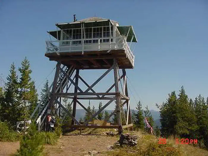
About ARID PEAK LOOKOUT
Overview Arid Peak Lookout was built in 1934 to help detect fires that may have been sparked by the Milwaukee Railroad Line. It was last staffed in 1969 and sat idle for over 25 years before being renovated by a team of over 30 volunteers, the Forest Fire Lookout Association and the U.S. Forest Service. Arid Peak Lookout was restored to its original splendor in 1997 and is available for rent to the public. The lookout is listed on the National Register of Historic Lookouts and provides epic 360 degree views of the Bitterroot Mountains. Access to the cabin requires a moderately-steep 3 mile hike and availability is dependent on weather conditions. Recreation The Hiawatha Bicycle Trail is considered the "crown jewel" of rail-to-trail mountain biking trails as it zips across seven trestles and through 10 tunnels in the magnificent Bitterroot Mountains. The trail can be accessed just over 10 miles from the lookout. The lookout offers access to the Arid Peak Trail #173, Mozier Peak Trail #174, and Kyle Creek Trail #175. All three trails are great for day-hiking, but can also be explored over longer backpacking treks or on horseback. Facilities The cabin fits up to four guests. Furnishings include two cots with mattresses, basic cooking gear, dishes, a propane lantern, propane camp stove, water containers, a table with two chairs and a wood stove. Anouthouse is located outside the tower.No water is available so guests must bring their own or boil and treat stream water. Propane canisters are not included; a stock of 16.4 ounce canisters are required to use cooking and lighting equipment. Other items to pack include bedding, food, binoculars, a first aid kit, flashlights, towels, toilet paper, and dish soap. Natural Features The Arid Peak Lookout is located within the St. Joe River area of the Idaho Panhandle National Forests, an area that includes most of what was originally established as the St. Joe National Forest. The area is known for its blue-ribbon cutthroat trout
How to Get There
From Avery, turn left and head north up the North Fork of the St. Joe River Road #456 toward Wallace. Travel about 4.5 miles, then turn left down the hill just before the bridge across the river. You will then be on Road #1997, which is a single lane gravel road with pull outs. Drive about 3.5 miles and turn left on the first road (also labeled Road No. 1997). Travel 6.5 miles to Trailhead #175. A turn-around is just past the trailhead before the gate. Do not block the turnaround or the gate. Park in the wide spot by the trailhead. Hike up Trail #175 for 1.5 miles to the junction with Trail #173. Turn right and hike 1.5 miles on Trail #173 to Arid Peak.
Driving directions (Google Maps) →What to Pack for Your Stay
Tuned to the live forecast for this park.
👔 What to Wear
- 👕
Long-sleeve shirt
Synthetic or merino, sun-protective.
- 🧥
Light shell or windbreaker
Even on warm days, wind can chill (avg wind 9 mph).
- 👖
Hiking pants or convertible
Layer for variable conditions.
- 🥾
Trail runners or low boots
Comfortable, broken in.
- 🌡
Layers for swings
Daily temp range is wide (43°F low → 66°F high). Pack layers.
🎒 What to Pack
- 💧
Water
Bring at least 1L of water; more in heat.
- 🍫
High-energy snacks
A snack for the trail.
- 🧴
Sun protection
Sunscreen, sunglasses, brimmed hat.
- 🩹
First-aid kit
Blister patches, ibuprofen, tape, antiseptic wipes.
- 🗺
Offline map
Download your route in advance via Gaia, Caltopo, or OSM-based apps.
Recommendations adapt to the current forecast + trail stats. Use them as a starting point — local conditions, your experience, and the time of day you start all matter.
Plan Your Visit to ARID PEAK LOOKOUT
Heading to ARID PEAK LOOKOUT? A few things to know before you go:
- Reservations: popular sites fill up fast — check Recreation.gov 6 months in advance
- Fees: day-use and camping fees vary; check current rates on the official park page
- Trash & pack-out: follow Leave No Trace principles
- Wildlife: store food in bear boxes where provided; never feed wildlife
- Weather: the 5-day forecast above is updated every 6 hours; verify just before you go
Frequently Asked Questions
Do I need a reservation for ARID PEAK LOOKOUT?
No central reservation system listed for ARID PEAK LOOKOUT. Check the official page (https://www.recreation.gov/camping/campgrounds/234447) for the latest entry policy and availability.
How do I get to ARID PEAK LOOKOUT?
From Avery, turn left and head north up the North Fork of the St. Joe River Road #456 toward Wallace. Travel about 4.5 miles, then turn left down the hill just before the bridge across the river. You will then be on Road #1997, which is a single lane gravel road with pull outs. Drive about 3.5 miles and turn left on the first road (also labeled Road No. 1997). Travel 6.5 miles to Trailhead #175. A…
How do I contact ARID PEAK LOOKOUT?
You can reach the park at phone: 208-245-4517.
References & Official Resources