About RUNNING DEER CAMPGROUND
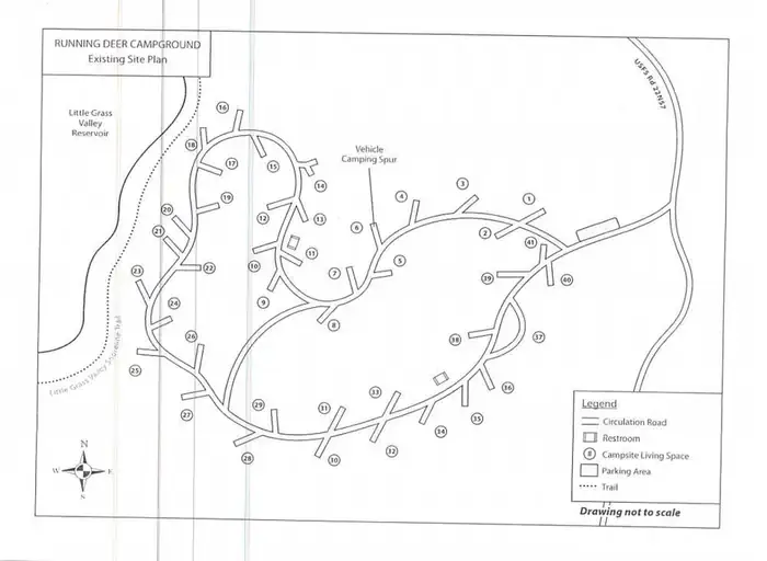
Overview Running Deer Campground is located on the eastern shore of the Little Grass Valley Reservoir, giving visitors ample opportunity to fish, swim, boat and enjoy nature. It is one of eight campgrounds in the area, providing access to a beautiful mountain lake and various hiking, mountain biking and horseback riding trails that meander through the scenic hills and valleys.Recreation The 1,615-acre lake provides ample opportunities for visitors to fish, boat, swim and water ski. Anglers can expect a catch of a variety of trout and kokanee salmon, among other species of fish. The Lakeshore Trail, which loops 14.5 miles around the lake, is available for hiking, mountain biking and horseback riding. The trail connects to the Pacific Crest National Scenic Trail, which stretches from 2,650 miles from Canada to Mexico, across three states. A variety of day hikes can be done on portions of the trail.Facilities The campground offers dozens of single-family campsites, available for tent and RV camping. More than a handful of the sites overlook the beautiful lake, while others are surrounded by various trees and shrubbery. A boat ramp is available within the site. Campsites are equipped with tables and campfire rings with grills. Flush toilets and drinking water are provided. Utility hookups are not available and all sites have paved parking spurs. Trash collection bins are available throughout the campground.Natural Features The campground is located in the Northern Sierra Nevada Mountains of northern California at an elevation of about 5,000 feet. It is adjacent to the Little Grass Valley Reservoir, which was formed by flooding in the 1960s. The campground and the lake are surrounded by thick stands of pine and fir trees. There are multiple campgrounds located around the lake as well as cabins on the south side. The campground is also the center of a popular snowmobiling area during winter months. Nearby Attractions About 12 miles northeast of the lake lies a small, natu
How to Get There
From Oroville, California, travel east on Highway 162 to Olive Highway. Turn right and continue 5 miles to Forbestown Road. Turn right and go 16 miles to La Porte Road. Turn left and travel 27 miles to La Porte, then 2 miles to signs for the recreation area. Turn right and continue just over 2 miles to the campground.
Driving directions (Google Maps) →Campsites at RUNNING DEER CAMPGROUND
41 campsites at this campground.
Showing 24 of 41 campsites.
What to Pack for Your Stay
Tuned to the live forecast for this park.
👔 What to Wear
- 👕
Moisture-wicking T-shirt
Light color, breathable.
- 🩳
Lightweight shorts or pants
Quick-dry preferred — sweat dries fast.
- 🧢
Brimmed sun hat
Better than a cap for back-of-neck protection.
- 🥾
Trail runners
Breathable mesh uppers.
🎒 What to Pack
- 💧
Water
Bring at least 1L of water; more in heat.
- 🍫
High-energy snacks
A snack for the trail.
- 🧴
Sun protection (UV 6)
SPF 50+ sunscreen, lip balm w/ SPF, sunglasses, sun hat.
- 🩹
First-aid kit
Blister patches, ibuprofen, tape, antiseptic wipes.
- 🗺
Offline map
Download your route in advance via Gaia, Caltopo, or OSM-based apps.
Recommendations adapt to the current forecast + trail stats. Use them as a starting point — local conditions, your experience, and the time of day you start all matter.
Plan Your Visit to RUNNING DEER CAMPGROUND
Heading to RUNNING DEER CAMPGROUND? A few things to know before you go:
- Reservations: popular sites fill up fast — check Recreation.gov 6 months in advance
- Fees: day-use and camping fees vary; check current rates on the official park page
- Trash & pack-out: follow Leave No Trace principles
- Wildlife: store food in bear boxes where provided; never feed wildlife
- Weather: the 5-day forecast above is updated every 6 hours; verify just before you go
Frequently Asked Questions
Do I need a reservation for RUNNING DEER CAMPGROUND?
No central reservation system listed for RUNNING DEER CAMPGROUND. Check the official page (https://www.recreation.gov/camping/campgrounds/233728) for the latest entry policy and availability.
How many campsites are at RUNNING DEER CAMPGROUND?
RUNNING DEER CAMPGROUND has 41 campsites. Site amenities (hookups, vehicle limits, ADA access) vary — see the individual campsite pages for details.
How do I get to RUNNING DEER CAMPGROUND?
From Oroville, California, travel east on Highway 162 to Olive Highway. Turn right and continue 5 miles to Forbestown Road. Turn right and go 16 miles to La Porte Road. Turn left and travel 27 miles to La Porte, then 2 miles to signs for the recreation area. Turn right and continue just over 2 miles to the campground.
How do I contact RUNNING DEER CAMPGROUND?
You can reach the park at phone: 530-534-6500.
References & Official Resources