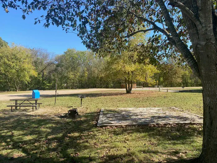
Overview Campers will delight in the picturesque river views at Tyler Bend. Located 11 miles (18 km) northwest of Marshall, Arkansas, Tyler Bend is set on a quiet, peaceful section of the great Buffalo National River. Known as the middle river region, the campground offers tranquil views of the river beside pastures. R…
Overview Campers will delight in the picturesque river views at Tyler Bend. Located 11 miles (18 km) northwest of Marshall, Arkansas, Tyler Bend is set on a quiet, peaceful section of the great Buffalo National River. Known as the middle river region, the campground offers tranquil views of the river beside pastures. Recreation Small-mouth bass, catfish and sunfish are the most popular fish to catch on the Buffalo River, but visitors should be aware that an Arkansas fishing license is required to fish anywhere on the river. The middle river location also allows for extended seasons for kayaking and tubing. If there's enough rain, the sports can go through mid- to late summer. Get a dose of history by hiking to the Collier Homestead, a restored Ozark dwelling from the 1930's. The homestead remembers one of the homes built by settlers in response to the Homestead Act of 1862.For current paddling conditions, please check with an outfitter (visit our Guided Services web page ), call the Tyler Bend Visitor Center at 870-439-2502, or check the Buffalo National River Float Guide DashboardFacilities The Tyler Bend Visitor Center is open year-round and has interesting exhibits on the history of flora and fauna in the Buffalo National River area. It's the primary visitor center for the region and provides several educational programs in the auditorium. The campground has 10 walk-in and 28 drive-in sites available, plus a day-use pavilion and five group sites.Natural Features The Buffalo National River flows free over swift running rapids and quiet pools for its 135-mile (217 km) length. One of the few remaining rivers in the lower 48 states without dams, the Buffalo cuts its way through massive limestone bluffs traveling eastward through the Arkansas Ozarks and into the White River. Nearby Attractions The Buffalo River Trail is accessible from the Collier trailhead parking area. This trail joins the Ozark Highlands Trail at Woolum, 14 miles (22.5 km) upstream from Tyler Bend.
Photos
Tyler Bend Camp Site — NPSTyler Bend Group Sites — NPSTyler Bend Campground — NPS
How to Get There
From Springfield, Missouri take U.S. Highway 65 south for 109 miles (175 km); then turn right at Ranger Road (follow signs) and drive another 2 miles (3.2 km) to visitor center and campground. From Little Rock, Arkansas take Interstate 40 West for 34 miles (55 km), then exit "U.S. 65/Skyline Drive." From here continue on U.S. Highway 65 north for 74 miles (119 km) and turn left at Ranger Road (follow signs) to the visitor center and campground.
Download your route in advance via Gaia, Caltopo, or OSM-based apps.
Recommendations adapt to the current forecast + trail stats. Use them as a starting point — local conditions, your experience, and the time of day you start all matter.
Plan Your Visit to TYLER BEND CAMPGROUND
Heading to TYLER BEND CAMPGROUND? A few things to know before you go:
Reservations: popular sites fill up fast — check Recreation.gov 6 months in advance
Fees: day-use and camping fees vary; check current rates on the official park page
Trash & pack-out: follow Leave No Trace principles
Wildlife: store food in bear boxes where provided; never feed wildlife
Weather: the 5-day forecast above is updated every 6 hours; verify just before you go
Frequently Asked Questions
Do I need a reservation for TYLER BEND CAMPGROUND?
No central reservation system listed for TYLER BEND CAMPGROUND. Check the official page (https://www.recreation.gov/camping/campgrounds/233119) for the latest entry policy and availability.
How do I get to TYLER BEND CAMPGROUND?
From Springfield, Missouri take U.S. Highway 65 south for 109 miles (175 km); then turn right at Ranger Road (follow signs) and drive another 2 miles (3.2 km) to visitor center and campground. From Little Rock, Arkansas take Interstate 40 West for 34 miles (55 km), then exit "U.S. 65/Skyline Drive." From here continue on U.S. Highway 65 north for 74 miles (119 km) and turn left at Ranger Road (fol…
How do I contact TYLER BEND CAMPGROUND?
You can reach the park at phone: 870-439-2502 or email: [email protected].