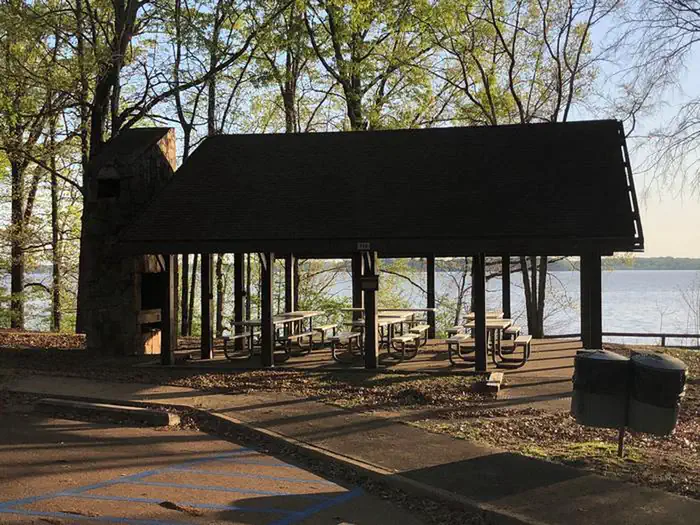
Overview Bayou Point Day Use Area sits along Arkabutla Lake and Dam in the hills of northwest Mississippi. The dam project is on the Coldwater River and offers some of the best sailing east of the Mississippi River. Recreation Families come to Arkabutla Lake to enjoy the great outdoors by fishing, boating, swimming, hi…
Overview Bayou Point Day Use Area sits along Arkabutla Lake and Dam in the hills of northwest Mississippi. The dam project is on the Coldwater River and offers some of the best sailing east of the Mississippi River. Recreation Families come to Arkabutla Lake to enjoy the great outdoors by fishing, boating, swimming, hiking, and biking. Wildlife management areas around Arkabutla Lake boast a combined 30,000 acres of public hunting lands where whitetail deer, wild turkeys, quail and waterfowl roam. Several trails wind around the lake and throughout the nearby landscape. The Coldwater River Nature Trail System encompasses two hiking trails as well as an interpretive trail that helps educate hikers on the wildlife and ecosystem. The Swinging Bridge Nature Trail is also nearby, and includes a section of land that was part of the river prior to the dam being built. This trail is also an interpretive educational trail. Thousands of people each year visit Arkabutla Lake to go fishing. The lake is home to several species of native fish to Mississippi waters, such as largemouth bass, bream, catfish and crappie. Natural Features The pavilions are situated near the waterfront, among rolling hills forested with a shady mixture of oak, hickory, beech, sweet gum and birch trees.
Photos
Pavilion 710 — Ranger Jamie Richmond
How to Get There
Bayou Point is located on Scenic Loop 304 near the entrance to Arkabutla Dam.
Download your route in advance via Gaia, Caltopo, or OSM-based apps.
Recommendations adapt to the current forecast + trail stats. Use them as a starting point — local conditions, your experience, and the time of day you start all matter.
Plan Your Visit to Bayou Point Day Use
Heading to Bayou Point Day Use? A few things to know before you go:
Reservations: popular sites fill up fast — check Recreation.gov 6 months in advance
Fees: day-use and camping fees vary; check current rates on the official park page
Trash & pack-out: follow Leave No Trace principles
Wildlife: store food in bear boxes where provided; never feed wildlife
Weather: the 5-day forecast above is updated every 6 hours; verify just before you go
Frequently Asked Questions
Do I need a reservation for Bayou Point Day Use?
No central reservation system listed for Bayou Point Day Use. Check the official page (https://www.recreation.gov/camping/campgrounds/10122577) for the latest entry policy and availability.
How many campsites are at Bayou Point Day Use?
Bayou Point Day Use has 2 campsites. Site amenities (hookups, vehicle limits, ADA access) vary — see the individual campsite pages for details.
How do I get to Bayou Point Day Use?
Bayou Point is located on Scenic Loop 304 near the entrance to Arkabutla Dam.
How do I contact Bayou Point Day Use?
You can reach the park at phone: (662) 561-6261 or email: [email protected].