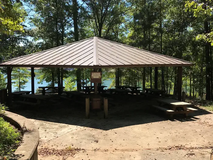
About HOUSTON SHELTER
Overview Houston Shelter is a group picnic site nestled on the shore of Lake Lewis Smith in Bankhead National Forest. This is a popular recreation area offering a variety of activities. Shelter is first come first served. Site is walk-up only.Recreation Day users can enjoy a beautiful sand swimming beach. Other activities include motorized and non-motorized boating and water skiing. Anglers can fish for Kentucky Spotted Bass and Hybrid Striped Bass. There are also hiking trails in the area, including the 1.4 mile High Rock Loop and the nearly 2 mile Fox Run Loop. Facilities The picnic facility offers tables, flush toilets, grills and drinking water. A boat ramp and showers are nearby.Natural Features Bankhead National Forest is located in northwestern Alabama. The prominent feature of the area is the Sipsey Wilderness. Known as "The Land of a Thousand Waterfalls," the Sipsey Wilderness encompasses an area of abundant streams, old-growth forests, limestone bluffs and lush canyons. Lake Lewis Smith boasts more than 500 miles of shoreline marked by high rock bluffs. The water is clear and deep and provides excellent fishing.
How to Get There
About 50 miles southwest of Decatur, take Highway 278 east from Double Springs for 8 miles. Turn south on County Road 63 and continue for 4 miles. Turn right onto Forest Service Road 118 and travel a mile to the campground.
Driving directions (Google Maps) →Campsites at HOUSTON SHELTER
1 campsites at this campground.
What to Pack for Your Stay
Tuned to the live forecast for this park.
👔 What to Wear
- 👕
Moisture-wicking T-shirt
Light color, breathable.
- 🩳
Lightweight shorts or pants
Quick-dry preferred — sweat dries fast.
- 🧢
Brimmed sun hat
Better than a cap for back-of-neck protection.
- 🥾
Trail runners
Breathable mesh uppers.
- ☔
Rain jacket / shell
50% chance of precipitation in the forecast.
🎒 What to Pack
- 💧
Water
Bring at least 1L of water; more in heat.
- 🍫
High-energy snacks
A snack for the trail.
- 🧴
Sun protection (UV 6)
SPF 50+ sunscreen, lip balm w/ SPF, sunglasses, sun hat.
- 🩹
First-aid kit
Blister patches, ibuprofen, tape, antiseptic wipes.
- 🗺
Offline map
Download your route in advance via Gaia, Caltopo, or OSM-based apps.
- 🛍
Dry bags for electronics
Phone, camera, and snacks should stay dry.
Recommendations adapt to the current forecast + trail stats. Use them as a starting point — local conditions, your experience, and the time of day you start all matter.
Plan Your Visit to HOUSTON SHELTER
Heading to HOUSTON SHELTER? A few things to know before you go:
- Reservations: popular sites fill up fast — check Recreation.gov 6 months in advance
- Fees: day-use and camping fees vary; check current rates on the official park page
- Trash & pack-out: follow Leave No Trace principles
- Wildlife: store food in bear boxes where provided; never feed wildlife
- Weather: the 5-day forecast above is updated every 6 hours; verify just before you go
Frequently Asked Questions
Do I need a reservation for HOUSTON SHELTER?
No central reservation system listed for HOUSTON SHELTER. Check the official page (https://www.recreation.gov/camping/campgrounds/231991) for the latest entry policy and availability.
How many campsites are at HOUSTON SHELTER?
HOUSTON SHELTER has 1 campsites. Site amenities (hookups, vehicle limits, ADA access) vary — see the individual campsite pages for details.
How do I get to HOUSTON SHELTER?
About 50 miles southwest of Decatur, take Highway 278 east from Double Springs for 8 miles. Turn south on County Road 63 and continue for 4 miles. Turn right onto Forest Service Road 118 and travel a mile to the campground.
How do I contact HOUSTON SHELTER?
You can reach the park at phone: 205-489-5111.
References & Official Resources